Red Lodge, Montana
What is it like to drive the Beartooth Highway between Red Lodge and Cooke City, and what should I know before I do?
The Beartooth Highway is US 212 between Red Lodge and Cooke City, 68 miles over Beartooth Pass at 10,947 feet, the highest drivable point in Montana. It closed early for the season at 2:30 p.m. on Friday, October 9, 2026, ahead of a snowstorm, three days before the scheduled October 12 close. A November traveler cannot drive it. Expect it shut until late May 2027, and check Montana 511 before you plan a summer drive.
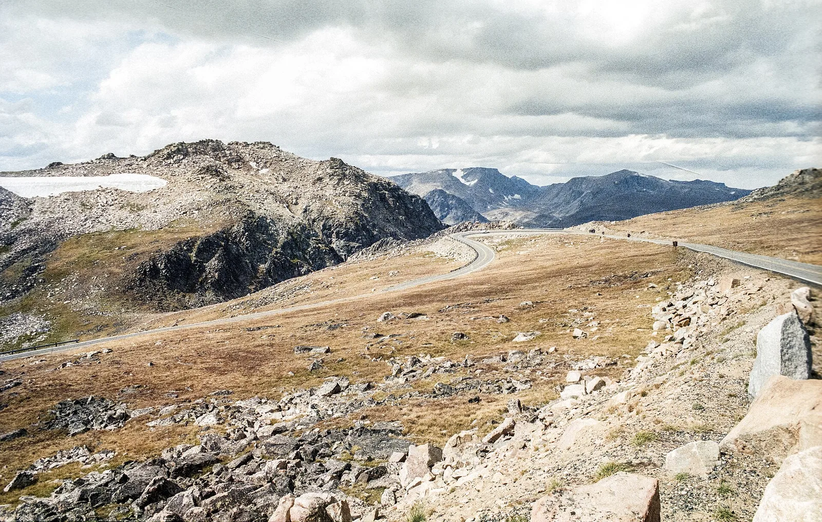
US 212 between Red Lodge and Cooke City runs 68 miles over Beartooth Pass at 10,947 feet. The road opened June 14, 1936, and carries the All-American Road designation. The National Park Service projected a 2026 season of May 22 to October 12, the full road opened May 23, and Montana DOT closed it early at 2:30 p.m. on Friday, October 9, 2026, ahead of a snowstorm. No 2027 dates are published yet. The climb out of Red Lodge gains more than 5,700 vertical feet in about 12 miles of switchbacks, from about 5,200 feet in town to the pass at the Wyoming state line. Driving time is at least two hours without stops, four to five with photo stops. There are no gas stations on the highway itself, cell service is unreliable to nonexistent across much of the plateau, and the road is closed for the season in November, so the night question is a summer question.
The season, and the November picture
The National Park Service projected the 2026 season as May 22 to October 12, the normal pattern being the Friday of Memorial Day weekend to mid-October. The full road opened May 23, 2026, and closed early at 2:30 p.m. on Friday, October 9, ahead of a snowstorm. Expect it shut until late May 2027. No 2027 dates are published yet, so the late May 2027 reopening is an expectation here, not a date.
A November traveler cannot drive it. The alternate route between Red Lodge and Cooke City and Yellowstone's Northeast Entrance is the Chief Joseph Scenic Byway, WY 296, per secondary sources. Winter at the Cooke City end closes the 9 miles of US 212 from Cooke City to Pilot Creek to wheeled vehicles, oversnow travel only. The companion story on winter access to Cooke City covers that end in full.
Do not treat this page as a live road conditions report. Check Montana 511 at 511mt.net or by dialing 511 for the Montana sections, and WYDOT 511 for the Wyoming sections, before you set out. The National Park Service lists (307) 344-2117 as its recorded road information line.
The three stretches, Red Lodge to Cooke City
The climb out of Red Lodge is about 12 miles of the tightest switchbacks on the highway, up the granite face, gaining more than 5,700 vertical feet.
After the pass comes a broad, mostly flat alpine plateau at or near 10,000 feet, dotted with glacial lakes, before the descent into Wyoming and the loop back into Montana toward Cooke City. Colter Pass, on the Cooke City side, is a Forest Service interpretive-sign stop (mile post 7).
Guardrails sit along most of the exposed sections, with genuine drop-offs beyond those rails, per one secondary source. That claim is secondary only. Do not read it as an agency statement. No guardrail claim for a specific stretch is made here without an agency or dated direct source.
Where to stop, and where you cannot
Rock Creek Vista turnout is a paved pullout about 12 miles out of Red Lodge, where the switchbacks stack below, per a secondary source. Twin Lakes Overlook is the marquee stop on the plateau, per the same source. Pullouts appear frequently on the descent toward Cooke City, per another secondary source. The Forest Service brochure counts 18 turnouts with interpretive signs along the road between the Northeast Entrance and Red Lodge. No mile points for pull-offs are given here.
Do not stop in the travel lane for a photo. A driver who needs to stop, let a faster car pass, or deal with a flat needs to know before the steep section, not during it. The plateau has pullouts, but the steep climb has few safe places to stop, and the road is too narrow for a car in the travel lane to be passed safely.
Weather, wildlife, altitude, and no cell service
Snowstorms can occur even in midsummer, with strong winds and severe thunderstorms at this elevation. Snow is possible any month the road is open. The temperature drops 15 to 20 degrees between Red Lodge and the summit, so plan layers. Rock debris and sand collect in the apex of blind corners, especially early in the season, and lingering ice or wet patches sit in shaded sections even in summer.
Elk, moose, mountain goats, marmots, and occasionally bears cross or stand on the road without warning. Altitude sickness is a risk for susceptible people with such a rapid increase. Cell service is unreliable to nonexistent across much of the plateau, so do not count on navigation or emergency calls working above treeline. Bring a physical map.
Larger vehicles: no rule found, drivers disagree
No Montana DOT or National Park Service vehicle-size rule for this road was found. Forum consensus is split and anecdotal. Many experienced RVers say do not take a motorhome or trailer over it, citing brake heat on the descent, mirror clearance, holding up traffic, and pullouts too small when crowded. Others report doing it in 25 to 45 foot rigs without trouble. One account reports being towed down the switchbacks after brakes overheated towing a 22 foot trailer.
No vehicle-size rule is listed here, because none was sourced. The honest line is the split itself: no published restriction found, experienced drivers disagree, and the practical advice, low gear, pullouts to let faster vehicles pass, brakes over throttle, comes from dated traveler reports, labeled as such.
After dark
No dated agency or local source was found on night driving the Beartooth specifically. None is invented here. What is sourced: no lighting is documented, cell service is unreliable above treeline, and the road is closed for the season in November, so the night question is a summer question.
If something goes wrong
No verified tow operator number was found for this road. The only Red Lodge towing result surfaced is a generic SEO page advertising a 24/7 number, which reads like lead-generation content, not a verified local operator. That number is not listed here. A Hardin operator serves Big Horn County and I-90, not the Beartooth, and is too far to be useful here.
No verified tow operator was found for this road, so no tow number is listed here. For help on the Red Lodge side, Carbon County Sheriff dispatch is (406) 446-1234. Call 911 in an emergency. Help is a long wait on the plateau with no cell service, so save any tow number before leaving town, because the pass is no place to search for one.
Fuel and services at each end
There are no gas stations on the highway itself. Fuel up in Red Lodge or Cooke City. In Red Lodge, Circle 17, also signed Sinclair, at 1022 S Adams Ave, runs daily 6:00 a.m. to 7:00 p.m., (406) 446-2553, and calls itself the last stop til the top, per the station listings. Cenex Zip Trip at 902 Broadway Ave runs daily 6:00 a.m. to 10:00 p.m., (406) 446-0338, per the station listings. Hours as listed November 17, 2026; check before you drive.
In Cooke City, the Exxon at 204 Main St runs daily 8:30 a.m. to 5:30 p.m., (406) 838-2793, per the station listing. A second Cooke City Sinclair at 115 Main St E shows possibly temporarily closed in listings and is not listed. Cooke City counted 77 people in the 2020 census. Services are limited, and rooms, meals, and fuel need advance planning, especially outside July and August.
Before you set out
Fuel before leaving town. Red Lodge and Cooke City are the fuel stops; the highway itself has none. A charged phone matters, and so does a plan for where the drive ends, because the plateau has no services and long stretches have nowhere to stop.
Check Montana 511 or WYDOT 511 the morning you drive, and recheck if the weather turns. The 2026 season closed three days early with one storm. The road can shut the same way again.
Drive slow on the steep stretches, use turnouts for faster traffic, and drive it in daylight if you can. The mountain asks for a careful driver, not a fast one. The companion story on winter access to Cooke City covers the road's other end; the two link to each other rather than repeating each other.
Select a passage, then Share to send it with a link.
Questions, answered
- Is the Beartooth Highway open right now?
- No. It closed for the season at 2:30 p.m. on Friday, October 9, 2026, ahead of a snowstorm, three days before the scheduled October 12 close. Expect it shut until late May 2027. No 2027 dates are published yet. Check Montana 511 or WYDOT 511 before you plan a summer drive.
- How long is the Beartooth Highway between Red Lodge and Cooke City?
- 68 miles, the consistent figure across sources, with one source saying 69 and another giving a range of roughly 65 to 68 miles. Driving time is at least two hours without stops, four to five with photo stops. 68 miles is the figure used here, with the range noted.
- Does the Beartooth Highway have guardrails?
- Guardrails sit along most of the exposed sections, with genuine drop-offs beyond those rails, per one secondary source. That claim is secondary only, and no agency source for a specific stretch was found. No guardrail claim for a specific stretch is made here without an agency or dated direct source.
- Can I drive an RV on the Beartooth Highway?
- No Montana DOT or National Park Service vehicle-size rule was found, so no rule is printed here. Experienced drivers disagree: many say do not take a motorhome or trailer over it, citing brake heat, mirror clearance, and pullouts too small when crowded, while others report doing it in 25 to 45 foot rigs without trouble. Use low gear, pullouts to let faster vehicles pass, and brakes over throttle.
- Who do I call if my car breaks down on the Beartooth Highway?
- No verified tow operator number was found for this road, and none is listed here. The only Red Lodge towing result surfaced reads like lead-generation content, not a verified local operator. For help on the Red Lodge side, Carbon County Sheriff dispatch is (406) 446-1234. Help is a long wait on the plateau with no cell service. Call 911 in an emergency.
- Where can I pull off on the Beartooth Highway?
- The Forest Service brochure counts 18 turnouts with interpretive signs along the road. Rock Creek Vista turnout sits about 12 miles out of Red Lodge, where the switchbacks stack below, and Twin Lakes Overlook is the marquee stop on the plateau, per secondary sources. Pullouts appear frequently on the descent toward Cooke City. No mile points for pull-offs are given here.
Sources
Checked November 17, 2026.
- NPS news release, May 22, 2026: Beartooth Highway full opening May 23
- Custer Gallatin National Forest, Beartooth sign-map brochure: Colter Pass (MP 7), 18 turnouts with interpretive signs
- NPS, Yellowstone park roads, 2026 projected dates May 22 to Oct 12, updated Sept 17, 2026
- deeparrival.com, Beartooth Highway closure, Oct 2026: early shutdown, Chief Joseph alternate, NPS road line (307) 344-2117
- trippapps.com, seasonal road closures, checked Nov 11, 2026: closed for the season, MDT shut US-212 Oct 9
- Wikipedia, Beartooth Highway: 10,947 ft pass, opened June 14, 1936, at least two hours driving time
- switchback-moto.com, Beartooth Highway deep-dive, July 3, 2026, secondary
- roamingmontana.com, Beartooth Mountains and Cooke City pages, secondary
- alaskancampers.com, Beartooth Highway route notes, Dec 6, 2024, secondary
- iRV2 and Airforums threads, RV and trailer opinion, anecdotal only
- Station listings, Nov 17, 2026: Circle 17/Sinclair and Cenex Zip Trip, Red Lodge; Cooke City Exxon (406) 838-2793; Cooke City Sinclair status
More to read
- Cottonwood’s chocolate shop began in a Michigan kitchen
The Michigan kitchen behind a Cottonwood chocolate shop, with truffle fillings to explore and a box to take home.
- A bookshop with a life after the last page
A bookshop that still acts like a small arts institution. Open daily in the Saint George lobby, with a gallery show on the record in June 2026.
- A quieter night under St. Augustine’s lights
More than three million white lights, free, over the oldest city in the country. Go on a weeknight, park once, and walk.